
The litle train of the Rhune
 Aquitaine
|

|
 |  |
Genius Tour Search Engine:
|
|
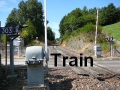
 The road traveled by the train Located along the Spanish-French border. Depart from the lower station (altitude 189 m), then passing through the ravine, Alchangu, the bog, forest and arrival at the station that is at 905 meters of altitude.  Col de Saint-Ignace, 64310 Sare Col of Saint-Ignace is located near the village of Sare in the Basque Country. The departure train station is located at the Col of Saint-Ignace, at about 10 km of Saint-Jean de Luz between Ascain and Sare. From Bayonne / Biarritz take the A63 direction to Saint Jean de Luz. Take the exit 2 Ciboure / Col d'Ibardin, and follow the N10 direction to Hendaye. Then turn left, follow the D4 direction to Ascain / Sare From Saint Jean de Luz Take the D918 direction to Ascain/Cambo les Bains. Turn towards Ascain then take the D4 direction to the Col of Saint Ignace From Dax : Take the N124 then the A63 direction to Bayonne/Biarritz/Saint Jean de Luz. Take the exit E Ciboure/Col d'Ibardin, and follow the N10 direction to Hendaye, then turn to the left, follow the D4 direction to Ascain/Sare. Access by bus : Departure of the road station of Saint Jean de Luz (in front of the train station). Sare : N 43°18'49'', O 01°34'45'' Click here to see the route (on a new tab)  |
 The minimum duration of the visit is 2 hours. The opening information of the train of Rhune is able to be accessed by clicking here. The ascent takes about 35 minutes. Visitors are free to choose their train for the return trip. Descent by foot is possible and takes between 2 hours to 2 hours 30 minutes. Disclaimer : The management team of the destination has the possibility to change the opening days and hours without prior communication.  Car parks are at the immediate proximity of the departure station and on the road to Ascain. Refreshments and a restaurant near the departure and arrival stations (arrival in city of Ventas). Note that the climate between the two stations can widely vary: some warm clothes and protections against the rain if necessary are advised. Possibility of many walks starting from the summit (see IGN map N ° 1245 OT-TOP 25). The "green" path of the Rhune, specially designed (green signs) lets you down at feet until the station of the Col of Saint Ignatius. The "Guidebook of the Rhune" (on sale at the Shop) conceived from this path, allows you to discover the flora, fauna, and the unique history of this mountain. |